Los Hervideros is a stretch of lava cliff on Lanzarote's south-west coast, beside the LZ-703 road between the Salinas de Janubio and El Golfo, where the Atlantic surges into caves and tunnels in the rock and bursts out again as spray. It is free, open at any hour, and a short path with railed viewpoints lets you stand right above the water. On a day with a big swell it is one of the most dramatic natural sights in the Canary Islands; on a flat summer morning it can be surprisingly tame.
The name explains the idea. A hervidero is a place where something boils, from the Spanish verb hervir, and that is exactly how the sea looks here when a wave forces its way into a cave mouth: churning white water, a deep boom from inside the cliff, then a jet of spray through a gap in the roof. There is no visitor centre, no ticket and no café. You park beside the road, walk a few minutes over the rock, and watch.
Most people give it twenty minutes to half an hour as one stop on a drive round the south-west, with El Golfo's green lagoon a few minutes to the north and the salt pans of Janubio a few minutes to the south. This page explains how the place was made, how to pick a day when it is worth seeing, where to stand and where not to, and how to fit it into the rest of that coast.
Where a lava flow met the ocean
Everything you walk over at Los Hervideros is young rock. Between 1730 and 1736 a chain of eruptions in what is now Timanfaya National Park poured lava over roughly a quarter of Lanzarote, buried villages and farmland, and pushed the coastline out into the sea. Several of those flows ran downhill to the south-west and reached the water along this shore, and the cliffs here are where one of them cooled.
Lava that hits the sea does not set into a smooth wall. The outside of a flow cools and hardens first while molten rock keeps moving inside, so the cliff is riddled with hollows, tubes and weak layers of loose cinder sandwiched between harder sheets. For close to three centuries the Atlantic has been working on those weak spots. Waves have scoured out the cinder, opened the tubes into caves, and in places broken through the roof, so that a wave entering at sea level can escape upwards through a hole several metres inland. That is the blowhole effect, and it is why the spray at Los Hervideros sometimes erupts from the ground beside the path rather than from the cliff edge.
The colours tell the same story. The black is basalt; the rusty reds and browns are scoria in which the iron has oxidised; the occasional green-grey tinge on wet rock is algae. If you want the bigger geological picture of how islands like this rise from the seabed, our page on how the Canary Islands were formed sets it out.
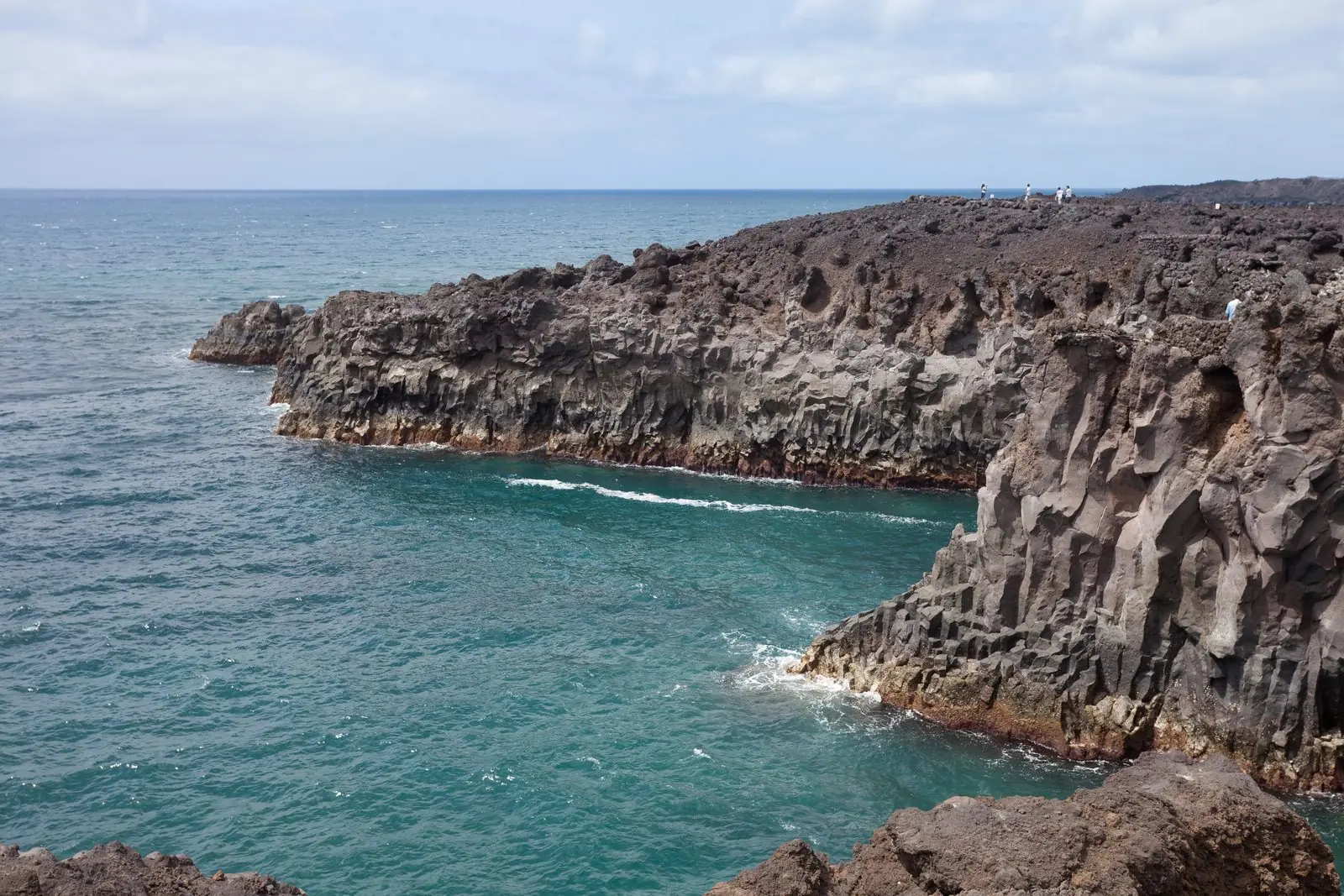
Photo: Luis Miguel Bugallo Sánchez (Lmbuga) · CC BY-SA 3.0 · Wikimedia Commons · scaled
What the walk is actually like
From the car park a path leads out over the lava, partly paved, partly stepped and partly bare rock, to a series of small viewing platforms with railings. The platforms sit on promontories between the inlets, so each gives a different angle: one looks straight down into a narrow channel, another faces a cave mouth, another looks along the cliffs towards El Golfo. The circuit is short, a few hundred metres at most, and it loops back to the road.
The surface is the main thing to plan for. Volcanic rock is sharp, uneven and gritty, and the steps are irregular, so trainers or walking sandals with a proper sole are much better than flip-flops. The path is not suitable for wheelchairs and is awkward with a pushchair; anyone unsteady on their feet can still see a good deal from the first platform, close to the road. There is no shade at all, and the wind on this coast can be strong enough to snatch a hat or a sun visor over the rail.
There are no toilets, no kiosk and no water on site. The nearest food and drink is in El Golfo village, a short drive north, where a row of fish restaurants faces the sea.
Picking a day when the sea is up
This is the part most visitors get wrong. Los Hervideros depends entirely on the swell, and the swell on Lanzarote's west coast varies enormously. The biggest days usually come between autumn and early spring, when Atlantic storms far to the north send long, powerful swells down towards the Canaries. In summer the sea on this side of the island is often much calmer, and you may see little more than a gentle slosh at the cave mouths. It is still a striking piece of coast, but it is not the show in the photographs.
Wind and swell are not the same thing. Lanzarote's trade wind blows from the north-east for much of the year and makes the island feel blustery, but it is the long-period groundswell arriving from the north-west that fires the blowholes. A still, sunny winter day after a distant storm can be far more spectacular than a windy day in July. Our explainer on wind in the Canary Islands covers the trade-wind pattern in more detail.
The tide matters too. At low water much of the swell breaks on the rocks before it reaches the caves; on a rising or high tide the waves drive straight in. If you can, aim for the two or three hours around high tide on a day when a surf forecast shows a decent swell for the west coast. Any tide table or surf forecasting app for Lanzarote will give you both.
Let the coastal warning choose your afternoon. Spain's national weather service, AEMET, issues warnings for "fenómenos costeros" (coastal phenomena) by island, colour-coded yellow, orange and red, on its Meteoalerta pages. A yellow coastal warning for Lanzarote is about the best signal there is that Los Hervideros will be performing. It is also the signal to stay firmly behind the railings, and on orange or red days to watch from the first platform by the road or not go out at all.
Where to stand, and where not to
The railed platforms are there for a reason. Waves at Los Hervideros do not arrive at a steady size; every so often a set comes through that is far bigger than the ones before it, and on a big day the water and spray can reach well above the level where people stand. The rock is slippery wherever it is wet, and a fall onto lava, or into the water inside an inlet, is very serious: there is no beach to wash up on, only cliff and cave.
Some visitors climb over the barriers or wander off the path to get closer to the edge for a photograph. Do not follow them, and keep a hand on children near the rails. If you see spray landing on a stretch of rock, assume a bigger wave will land there soon. The best photographs are usually taken from the higher platforms anyway, because they let you frame the whole cave and the burst of white water against the black cliff.
Be careful with drones. This coast lies within protected natural areas and close to Timanfaya, and flying over or near national-park land is restricted. If you want to fly, check the rules for the exact spot before you take off rather than assuming it is allowed.
The seventh wave is a myth; the rogue one is not. There is no reliable rhythm to the bigger waves at Los Hervideros. Families who have watched ten modest surges and stepped closer for the eleventh are exactly the people who get soaked or knocked over. Choose your spot before the set arrives, and stay there.
Getting there and parking
Los Hervideros is reached by car, or on an organised tour. The LZ-703 leaves the main LZ-2 near the salt pans of Janubio and runs north along the coast to El Golfo, with Los Hervideros roughly in the middle of that stretch. The car park is directly beside the road on the sea side; it is unmarked except by the cars already in it and a sign for the viewpoint. On busy days around midday it fills, and people park along the verge, which is narrow. Arriving early or late in the day makes life easier.
From Playa Blanca the drive takes well under half an hour, which makes Los Hervideros an easy late-afternoon outing from the south of the island. From Puerto del Carmen or Costa Teguise allow longer, typically 35–50 minutes depending on traffic. The road itself is one of the best short drives on the island, with lava fields inland and the ocean on the other side; our round-up of the best scenic drives includes the Timanfaya route nearby.
Public transport is not a realistic option. Local buses serve Yaiza and Playa Blanca, but nothing runs along the coast road to the viewpoint, so without a car you need a tour or a taxi. Our page on car hire in the Canaries explains what to look for in a rental, and the car park is ordinary tarmac, so no special insurance issues arise.
How to build the south-west day around it
Los Hervideros makes most sense as one piece of a loop, and the stops are so close together that the order is largely about light. A typical day starts with a morning time slot at Timanfaya, which you must book online in advance, then drops down to the coast. From there the classic sequence runs:
- El Golfo: the half-crater with the green lagoon of Charco de los Clicos and its black beach, a few minutes north of Los Hervideros.
- Los Hervideros: twenty minutes to half an hour on the cliffs, longer on a big swell day.
- Salinas de Janubio: the chequerboard of salt pans around a lagoon, best seen from the viewpoint on the main road in late-afternoon light.
Driving south lets you finish with the salt pans and dinner in Playa Blanca; driving north lets you end at El Golfo, where the fish restaurants look straight into the sunset. The week-long Lanzarote itinerary puts the whole stretch into its second day.
Late afternoon: the light and the sunset
The coast here faces west and south-west, which makes the last couple of hours of daylight the most photogenic time to visit. Low sun lights the red rock and turns the spray gold, and the crowds from the morning Timanfaya slots have usually moved on. The sun goes down over the open Atlantic, with nothing between you and the horizon.
If sunset itself is the aim, El Golfo and the Janubio viewpoint are slightly easier places to linger, because they have somewhere to sit and, in El Golfo's case, a table and a drink. Our guide to the best sunset spots across the islands includes this coast. Leave Los Hervideros before the light goes completely: walking back over lava in the dusk is easy to misjudge.
Is it worth stopping?
Yes, as long as you treat it as a short stop rather than a destination in its own right, and you check the sea before you set out. On a calm summer day it is a pleasant ten-minute leg-stretch with good views; on a big winter swell it is the kind of place people talk about for the rest of the holiday, with the boom of each wave coming up through the rock and spray rising above the platforms.
It costs nothing, needs no booking and sits on the most rewarding stretch of road on Lanzarote. Put it between Timanfaya and El Golfo, go on a rising tide with the swell running, wear proper shoes and stay behind the rails, and you will see the island doing what it has done since the 1730s: lava and ocean still fighting over the same few metres of coast.