The Paisaje Lunar, the "lunar landscape", is a cluster of pale, eroded rock towers in the pine forest above Vilaflor in southern Tenerife, and the only signposted way to see it is on foot, by the PR-TF 72 circular trail from the village: about 12.9 kilometres and four to five hours of walking. No permit or booking is needed and there is no entry fee. What you need instead is a free day, good shoes, plenty of water, and a check that the area is not closed for one of the Cabildo's mouflon control days.
The towers themselves are made of compacted volcanic ash and pumice, cream to almost white, carved by rain and wind into columns, fins and narrow gullies. Many of the columns wear a darker stone on top, like a cap. Seen from the viewpoint at Los Escurriales, with the orange-brown trunks of Canary pines all around, they look less like the Moon than like a set built for a film that never got made.
It is a real walk rather than a roadside stop, and the effort keeps the crowds small. This page explains what you are looking at, how the trail runs, how long it takes, the shortcuts people talk about and why they are not the official route, and how to fit the day around Vilaflor and the drive up to Mount Teide.
Why the rock is white
Most of Tenerife's high country is dark: black and brown lava, red cinder cones, grey scree. The Paisaje Lunar is the exception because it is not lava at all. It is a deposit of ash and pumice thrown out by the great explosive eruptions of the old Las Cañadas volcano, the ancestor of today's Teide, which settled in thick layers on the southern slopes and compacted into a soft rock geologists call tuff. Our page on how the Canary Islands were formed explains how that older volcano collapsed and was replaced.
Differential erosion did the carving. Where a harder fragment of rock lies on top of the soft tuff, it shields the column beneath it from the rain, while the unprotected ash around it washes away. Once the cap falls off, the column below starts to dissolve, which is why you see towers at every stage, from tall capped spires to stumps and smooth humps. The tuff is so soft that you could scratch it with a fingernail. Please do not: every scratch, footprint and souvenir pebble speeds up erosion that took thousands of years.
Look at the caps, not just the towers. The darker stone balanced on top of each column is the reason it still stands. Spot a column whose cap has gone and you are looking at a tower that has started to disappear.
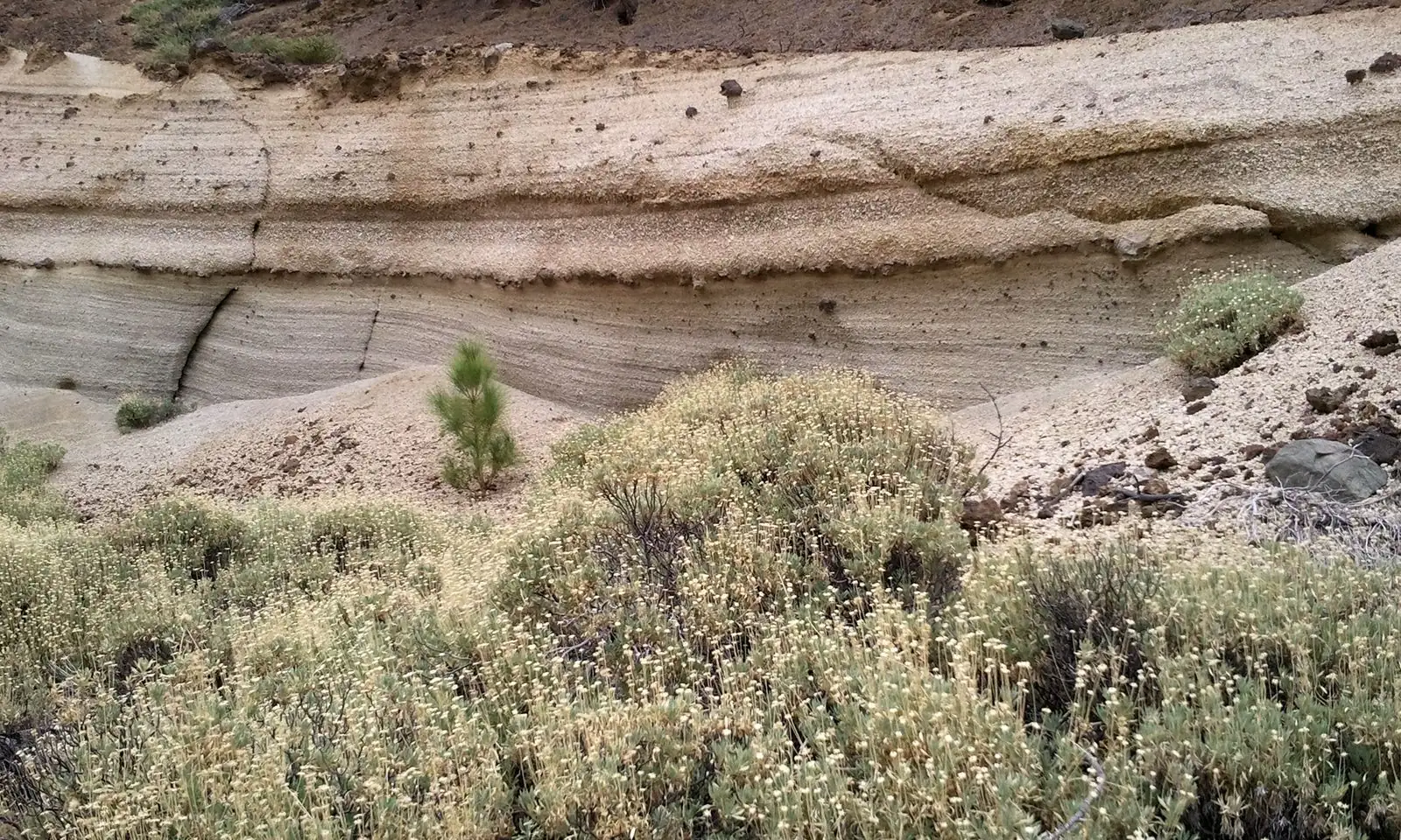
Photo: Dreol · CC BY-SA 3.0 · Wikimedia Commons · scaled
The PR-TF 72 loop at a glance
Officially, this is the PR-TF 72, Vilaflor – Paisaje Lunar – Vilaflor, a waymarked route approved by the Cabildo de Tenerife that needs no authorisation. It lies inside the Corona Forestal Natural Park, the belt of pine forest that rings the national park. The figures below are the Cabildo's, as published on the island's official tourism site.
- Distance: 12.9 km, circular.
- Height: lowest point about 1,381 m, highest about 1,967 m, with roughly 780 m of climbing in total.
- Time: about four hours by the Cabildo's estimate; the regional Chasna-Isora association allows five, and that is more realistic with stops.
- Difficulty: medium. The climb is long and steady rather than technical, but it is relentless for the first half.
- Start: the church square of San Pedro in Vilaflor.
- Cost: free; no ticket, no booking, no facilities on the way.
How the walk unfolds
You leave Vilaflor uphill on the Camino del Atajo, a stretch of the old Camino Real de Chasna, the mule path that once linked the south of the island with the Orotava valley over the mountains. Within minutes the village gardens give way to terraces and then to pine forest. The path passes the old house of Casa Galindo, crosses the Barranco de las Mesas and keeps climbing on a carpet of fallen needles, with wider views opening over the south coast and, on a clear day, across to La Gomera.
Most of the effort comes early. You gain most of the height in the first two hours, at altitudes where many visitors from sea level will notice their breathing. Take it steadily, drink before you are thirsty, and do not judge the route by how gentle the start looks. After the long ascent the trail reaches the Mirador de Los Escurriales, where the white towers appear below and around you. This is the place for lunch and photographs, and the reason for the whole outing.
The return loops back through the forest past the house of Los Llanitos before joining the outward path for the descent to Vilaflor. Downhill on loose needles and grit is tiring on the knees, so walking poles help. The trail links with the long-distance GR-131 and with the PR-TF 83 towards the heights of Granadilla, which is how experienced walkers stretch it into a full day; the route options are on our hiking on Tenerife page.
The shortcut from the TF-21, and why it is not official
Ask around and someone will tell you that you can see the Paisaje Lunar in an hour from the road. There is a popular short version that starts from a forest track near kilometre 66 of the TF-21, the road that climbs from Vilaflor towards Las Cañadas, and drops down through the pines to the formations. It is shorter, but it is not a signposted access in the Cabildo's trail register, the way back is uphill all the way, and parking on the verge of a mountain road is a poor idea on a busy day.
A second rumour concerns the forest track to Madre del Agua, which reaches closer to the formations. It is catalogued as a forest road open to motor vehicles under the island's 2018 rules for forest tracks, but whether private cars may use it on a given day depends on the Cabildo, and we could not confirm its current status. Forest tracks are also exactly where hire-car insurance tends to stop, as our page on hiring a car in the Canaries explains. If you want the shortest legal walk, ask the tourist office in Vilaflor on the day; if you want the real experience, walk the loop.
Closures: mouflon days, fire and wind
The trail is open almost every day of the year, with one local exception that hardly any guide mentions. The mouflon, a wild sheep introduced to the Teide uplands in the early 1970s, has become a serious threat to the park's rare plants, and the Cabildo runs controlled culls to keep numbers down. On those days the hunting area, which includes the Paisaje Lunar, is closed to walkers from 07:00 to 16:00. The Cabildo publishes the dates for each season in advance; published calendars for 2026 listed days in spring and again in October and November, so check the calendar on the Tenerife ON website before you set off.
In summer the forest can also be closed when the fire risk is extreme, and after heavy rain or strong winds, when falling branches and washed-out paths are a hazard. Tenerife has had big forest fires in recent years, and the authorities do not hesitate to shut trails when the risk rises. If a sign or a ranger says a path is closed, it is closed.
A shotgun is not something to argue with. If you hear shooting or meet a closure tape in the pines above Vilaflor, turn back. Mouflon culls are carried out by licensed hunters in the forest, and a trail closure on those days is about your safety, not paperwork.
When to go and what to take
Spring and autumn are the best seasons: mild enough to climb in comfort, usually clear, and with the forest smelling of resin. In winter the start is cool and the upper part can be cold, even frosty early in the day; in high summer the afternoons are hot and there is little shade around the formations. At any time of year, start early. Cloud often builds on the southern slopes from late morning, and the white rock is at its best in low, slanting light.
Carry at least two litres of water per person, food, sun cream, a hat and a warm layer, because there is nowhere to buy anything once you leave the village. Wear proper walking shoes with grip; the soft ash and pine needles are slippery on the descent. Mobile coverage is patchy in the barrancos, so tell someone where you are going, and save 112, the emergency number, in your phone. The Canary pines that shade the route are a story in themselves, told on our page about the Canary pine and its forests, a tree that survives fire by sprouting again from a scorched trunk.
Getting to Vilaflor
Perched at about 1,400 metres on the TF-21, Vilaflor de Chasna is roughly half an hour to forty minutes' drive up from Los Cristianos and the southern resorts, and it is the highest village in the Canary Islands. There is no dedicated trailhead car park. Leave the car in the streets of the old centre or near the church square: easy early in the morning, harder by mid-morning in high season. Our page on driving in the Canary Islands covers the hairpins and the etiquette of mountain roads.
Without a car, TITSA buses do climb to Vilaflor from the south, but services are few, and a missed last bus leaves you stranded at altitude. Check the current timetable on our page about buses in Tenerife and on TITSA's own site before you rely on one, and allow a generous margin for a walk that can run to five hours.
Making a day of it
Vilaflor itself deserves an hour. Its church square, the Pino Gordo, a giant Canary pine that is the village's pride, and a handful of bars serving hearty mountain food make it a natural place to finish. Our page on Vilaflor covers where to eat and stay.
If you have energy left, the TF-21 carries on up through the forest into Teide National Park, where the caldera opens out above the clouds. Doing both on the same day is ambitious, but a night in Vilaflor turns it into a fine two-day trip: the Paisaje Lunar one day, the cable car and perhaps a summit permit the next, with the night in between acclimatising you for the higher ground. On the high mountain, read up on how altitude affects you first.
Who the walk suits
The Paisaje Lunar rewards anyone reasonably fit who is happy with four or five hours on foot and a long climb. It is one of the most unusual sights on Tenerife, it costs nothing, and because it cannot be reached by coach, it is quiet even in high season. It is less suitable for young children, for anyone who struggles with sustained uphill walking at altitude, or for a short winter afternoon.
Start early from Vilaflor's church square, check the Tenerife ON calendar for closures, carry more water than you think you need, and keep your hands off the towers. Get those four things right and the white columns among the pines will be one of the memories you bring home from the island.