Fuente de los Azulejos is a roadside cliff of green, turquoise, ochre and violet rock on the GC-200, the mountain road between Mogán and La Aldea de San Nicolás in the south-west of Gran Canaria, and you see it simply by driving or riding the bus along that road. There is no ticket, no visitor centre and no opening time. The colours come from hot water that once seeped through volcanic ash inside an ancient collapsed volcano and slowly turned it into a mix of clays and minerals, each with its own shade.
The name means "fountain of the tiles". The azulejo is the glazed, often blue or green ceramic tile of Spain and Portugal, and the banded slopes beside the road look as if someone had laid a hillside in them. Locals often just call the place Los Azulejos, and you may also see it labelled Los Azulejos de Veneguera, after the valley nearby.
It is a short stop rather than a day out, and the best thing about it is the road you take to get there. This page explains what makes the rocks coloured, where to pull in without risking a bump with a coach on a blind bend, and how to build it into a drive along one of the most dramatic stretches of tarmac in the Canaries.
What you actually see from the road
Coming north from Mogán, the GC-200 climbs out of the valley in hairpins and threads between bare ridges. Then, quite suddenly, the brown and grey hillsides give way to slopes streaked in pale green and blue-green, cut by bands of rust, cream, mustard and a dull purple. The effect is strongest on a cut face close to the road, where the colours run in layers, and on the eroded slopes above, where they spill downhill in fans.
The colours change with the light. Early in the morning and late in the afternoon the greens look almost jade; at midday, under a high sun, everything flattens to pastel. After rain, which is rare here, the wet surface deepens every shade. If you have seen photographs that look impossibly saturated, they were probably taken in low light, or edited. In person it is subtler, and more impressive for being real rock.
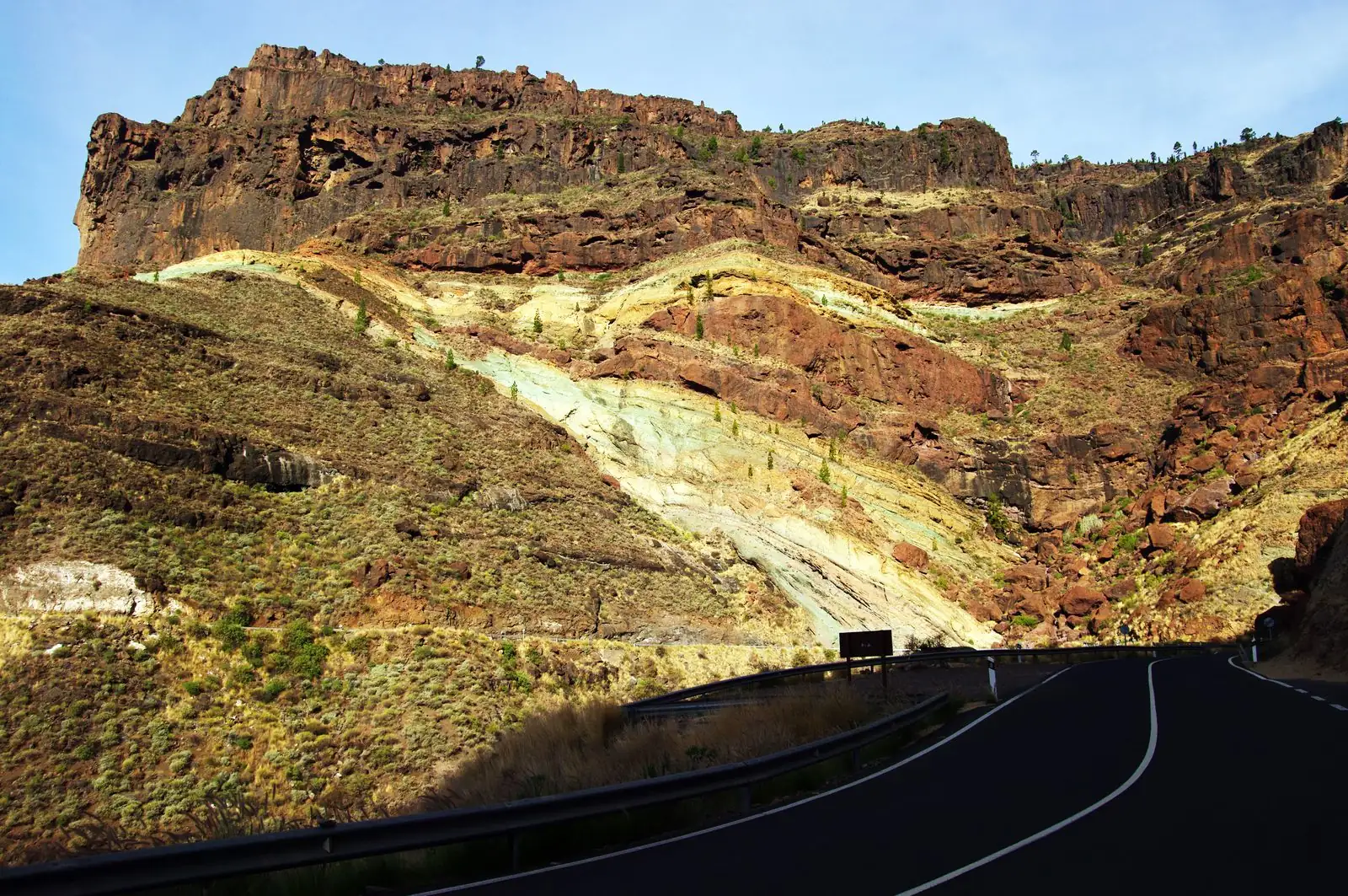
Photo: Bgabel · CC BY-SA 3.0 · Wikimedia Commons · scaled
Why the rocks are coloured
About 14 million years ago, the centre of Gran Canaria was a huge volcano that erupted so violently it emptied its own magma chamber and collapsed, leaving the vast basin geologists call the Tejeda caldera. Our page on how the Canary Islands were formed sets out the island's volcanic story. Inside the caldera, and along the fault that marks its edge, thick layers of very fine volcanic ash, a rock known as rhyolitic tuff, piled up.
Later, rainwater sinking into the ground was heated by the still-warm volcanic rocks below and began to circulate through the tuff, rising, cooling and sinking again in slow convection loops. This was not the boiling water of a geyser but warm water, moving for a very long time. It dissolved the volcanic glass in the ash and rebuilt it as new minerals. Studies of the Tejeda caldera's altered tuffs by Spanish university geologists list what that water left behind: zeolites, clay minerals such as smectite and illite, chlorite, quartz and feldspar, with iron oxides staining parts of the rock.
Reading the colours
Each family of minerals has its own colour. The greens and blue-greens come mainly from the clays and chlorite, the cream and white from zeolites, and the reds, ochres and purples from iron that has oxidised, in effect rusted, once the rock was exposed to air. The banding follows the original layers of ash and the paths the water took through them, which is why the colours run in stripes and patches rather than spreading evenly.
Gran Canaria is not the only island with a set. Tenerife has its own Los Azulejos, a smaller patch of blue-green altered rock inside Teide National Park, near the Roques de García, coloured by the same kind of hot-water alteration. If you have seen one, the other will look familiar; the Tenerife patch is mostly shades of green, while the Gran Canaria cliffs add the rusts, ochres and purples.
The white bits are the same family as cat litter. Zeolites, the pale minerals in the Azulejos, are porous crystals that trap water and other molecules. Mined elsewhere, they end up in water filters, animal feed and cat litter. Here they are part of a hillside, and the cliff is a natural cross-section through the plumbing of a long-dead volcano.
Where to stop safely
This is the part that matters most. The GC-200 here is a narrow mountain road with sharp bends, short sight lines, a rock wall on one side and a drop on the other. Buses and the occasional coach use it, and local drivers know it well and drive it briskly. Stopping on the carriageway to take a photograph, or swinging across the road into a gap that is too small, is how bumps happen.
Pull in only where there is a proper lay-by or a clear, wide verge with room to get the whole car off the road. Parking near the most colourful section is limited to a few small pull-offs that fill quickly in the middle of the day when tour groups pass, and it is easy to overshoot when you are watching the rocks rather than the road. If the space is full, carry on: the colours continue for some way, and there are other places a little further on where you can stop and walk back on the verge, keeping well in. Do not climb the slopes. The altered rock is soft and crumbly, it breaks away underfoot, and loose stones roll onto the road below.
Open the doors away from the traffic. In the small pull-offs near the Azulejos, one side of the car usually faces passing vehicles and the other a drop or a ditch. Get children out on the safe side, and step out only when you can see the road is clear in both directions.
The road itself: GC-200 from Mogán to La Aldea
The GC-200 runs from Mogán village north over the mountains to La Aldea de San Nicolás, on Gran Canaria's west coast, and it is one of the island's great drives. It climbs over a series of passes, the degolladas, between deep ravines that drop towards the sea, with turn-offs down narrow side roads to the remote valleys of Veneguera, Tasarte and Tasartico. The full run from Mogán to La Aldea takes well over an hour with stops, and longer if you are nervous on mountain roads.
It is a proper mountain road. Expect hairpins, stretches without a barrier, the odd fallen stone after rain, and very little in the way of fuel, food or toilets between the two towns. Fill up before you leave the coast. Occasional closures for rockfall or roadworks are posted by the Cabildo de Gran Canaria. Our page on driving in the Canary Islands covers mountain-road etiquette, and our round-up of scenic drives in the Canary Islands puts the GC-200 alongside the island's other classic routes.
By bus, without a car
You do not need a car to see the Azulejos. Global, Gran Canaria's bus company, runs line 38 between Puerto de Mogán and La Aldea de San Nicolás, and it follows the GC-200 past the colourful slopes. Services on this line are infrequent, so check Global's current timetable before you set out and plan your return first; our page on buses on Gran Canaria explains how the network and the fares work.
The bus will not stop for you to take photographs, and there is no stop beside the rocks with an easy way back. The bus is a way to see them from the window as part of a scenic ride, not a way to get out and explore. For that, you want a car or a tour.
Building it into a day on the west coast
The Azulejos make most sense as one stop on a longer loop. Start in Puerto de Mogán for an early coffee by the harbour, then drive up through Mogán village and onto the GC-200. After the Azulejos, consider the detour down to Playa de Veneguera, a wild, undeveloped beach at the end of a ravine, if the side road is open and you are comfortable with it.
Further on, La Aldea has the cactus garden at Cactualdea and the small harbour and pebble beach at Puerto de la Aldea, a good place for fish at lunchtime. Fit walkers with a spare day can reach the remote Güi Güi beach on foot from Tasartico, a hike that needs an early start and plenty of water. Our Gran Canaria itinerary shows how this west-coast day fits into a week on the island.
Drive it north in the morning. Leaving Mogán for La Aldea before about ten gets you through the narrowest bends before the tour traffic, while the morning light is still soft on the slopes. Coming back the same way late in the afternoon gives you a second, warmer look at the colours.
Who should make the detour
If you are staying in the south-west of Gran Canaria, around Mogán, Puerto Rico or Amadores, the Azulejos are close enough to make a morning drive worthwhile on their own, and a natural stop on any trip up the west coast. They suit anyone with an interest in geology or photography, and families who want a quick, free "wow" on a driving day. They suit less well anyone who hates mountain roads, because there is no gentle way in.
Treat it as a ten-minute stop on a two-hour drive rather than a destination in itself. Pull in only where the car is fully off the road, keep off the crumbling slopes, and give the light a chance by coming early or late. The road is the experience; the Azulejos are the moment on it that everyone remembers.